
Roberto Golović [1]
Budva, Montenegro
Abstract: Paper deals with analysis of the ancient Risan urban heritage, as well as with the manner in which that heritage reflects on the Romanisation of this, once, Illyrian city. Topography of the terrain in Risan and its immediate surroundings is described with a reflection on the way it conditioned the development of the city and contributed to its strategic significance. Text offers a review of the largest part of the most important archaeological findings in the domain of Illyrian and Roman architecture, while the other material evidences, due to the short form, were mentioned only when they directly contribute to determining the purpose of certain structure or its destiny. Such is the case with the horde of coins with the image of King Ballaios which indicates one violent episode from the ancient past of Risan. Although the city had central significance for the Illyrian (Ardiaeian) Kingdom during the wars with Roman Republic, in the third and second century BC, a conclusion emerges that it did not suffer any destruction. Upgrades that old Illyrian structures received during the time of the Principality suggests that life in these areas continued and transition from the Illyrian to the Roman time was peaceful. City’s uninterrupted prosperity, despite the loss of strategic importance for the new state in which it found itself, after a period of intermediate administration, is suggested by the very existance of a villa urbana in the immediate vicinity of the ancient core of the city.
Keywords: Risan, Risinium, Rhizon, Illyrian Wars, Roman architecture, Romanisation, Roman province, Urban archaeology, Villa of Hypnos
INTRODUCTION
The town of Risan is currently situated in Montenegro, but throughout history, it has changed hands more than a dozen times, being a site of continual habitation for over 10,000 years (Dyczek 2008: 189–197; Buzov 2011: 258–259; Kot 2013). Abundant archaeological evidence from the Neolithic period has been found both at the site of the town itself and in the caves in its immediate vicinity. The first time a takeover of Risan was recorded in history was during the Illyrian Wars (229–168 BC). In that context, Polybius describes the town of Rhizon (as it was known at the time) as a “place strongly fortified at a short distance from the sea and situated on the river Rhizon” (Polybius II. 11).
At the time of the first war against Rome, Risan’s stronghold was a refuge of choice for the Illyrian queen Teuta (228 BC), at other times (possibly henceforth) the town was the capital [2] of the Ardiaeian Kingdom, the most powerful Illyrian state [3] ever to arise. When the kingdom finally fell to the Romans in the Third Illyrian War (168 BC) “the strategically important city of Rhizon” as Livy puts it “was given exemption from taxes as well as freedom […] because it has gone over to the Romans” (Livy XLV. 26). The takeover was neither forced nor abrupt, as the town retained autonomy for more than a century while Rome seemed content on maintaining nominal control over the region through reliance on their allied tribes for maintaining order. Nonetheless, the next time Risan is mentioned by ancient historians it is as Risinium, oppida civium Romanorum (Pliny III. 144) meaning that it had a status of municipium or even a colonia.
This very transition from a residence of Illyrian monarchs to a town of the Roman province will be the focus of this essay. More specifically, the purpose is to show this transition as it was reflected in architecture and urban outline of the ancient city. To this end archaeological finds from the last two centuries will be examined. Although pottery, jewellery, statues, and similar material culture will be considered, such finds will remain excluded from the body of the essay due to its brevity. There has never been a systematic archaeological exploration of the entire town of Risan and its immediate hinterland. Some initial exploration was done by Vialla de Sommieres, a representative of French authorities during Napoleon Bonaparte’s rule over the region (De Sommieres 1820). However, since Arthur Evans conducted his first excavations in the 1870s while touring the Balkans as a war correspondent for the Manchester Guardian, exploration has continued, albeit in sections and campaigns often shortened by one of the wars.
Since the start of the century, persistent exploration, both on land and underwater, has been conducted by the Southeast European Centre for Archaeological Research Novae from Warsaw, under the direction of Piotr Dyczek, and it is planned to continue at least until the end of the decade. The intention is that, at the conclusion of the research, a comprehensive monograph, which is unjustifiably lacking in the case of Risan, is to be published. However, there is a large number of shorter articles and other works dealing with certain aspects of ancient Risan, and conclusions of this brief overview will be largely drawn from the analysis of those texts and archaeological evidence itself.

TOPOGRAPHY
The bay in which Risan is situated was known to the Greeks as Risonikos kolpos or as Sinus Rhisonicus to the Romans (Strabo 7.5.8), indicating that it was the most prominent settlement in the area during antiquity, and this is further affirmed by archaeological finds. The bay itself is formed from a constellation of smaller bays cut deeply into the Dinaric Alps which here appear to rise straight from the sea with little to no flatland in the foot of steep limestone cliffs. It comes as no surprise that the bay was often mistaken for a fiord (Evans 1885: 40), which would make it “the only fiord in the Mediterranean” (Luković 2013: 4). This, of course, was proven not to be true as it is simply an impressive case of an estuary, a sunken mouth of a river canyon.
Since Risan is situated in one of the most secluded parts of that bay, it was recently argued that its position was not strategically favourable, as the lack of visibility made it vulnerable to seaborne attacks.[4] This view does not appreciate the wider context as Illyrians are known to have operated networks of smaller coordinated forts,[5] and that strategy was used by others in the bay itself well into the 20th entury.[6] In fact, multiple other Illyrian hillforts are found in the bay,[7] of which at least two have a direct line of sight to the open sea, while the one above Risan could have been used as a citadel/fall-back position if the town itself was lost.
In Illyrian times, Risan primarily relied on its ships for defence, trade, and piracy. According to ancient sources, this reliance was the initial reason that attracted the hostility of Rome.[8] The location of Risan makes it an excellently positioned and easily defendable port. As Faber asserts “in strategic terms, Illyrians would not require any special sanctuary for the ships as the entire bay of Risan is considered as such” (Faber 1996: 107). Risan is more than twenty kilometres from the mouth of the bay and five kilometres from the Straits of Verige, which are only 300 m wide and could be barricaded if necessary (as was done multiple times by the Ottomans in the early modern period). This, on the other hand, is a two-edged sword as an enemy could try to blockade the city and its fleets from leaving the bay. This could have posed a challenge for the Romans during the Illyrian Wars, considering the difficulty of supplying the blockading force, but it was successfully done in more modern wars.
If a blockade were to take place, however, Risan had ample supply of water. From the east, it was bordered by a river; from the west, by a stream Through the well-defended mountain passes in the north, it was connected to Illyrian settlements inland, where it could presumably acquire other supplies (Faber 1996: 112). The river itself could have been used as a pier/ dock for ships, as was the case with nearby Kotor (most likely ancient Acruvium). No ancient piers were found, although some historians do assume they have existed and might have sunk as the landscape had suffered some dramatic changes over time. Evans, writing in 1870’s, noticed “a slight submergence of the land within the historic period” (Evans 1885: 40). This could have been a result of a devastating earthquake of 1667 that had brought down the bridge over river Spila (Kowal 2013: 50), or some prior unrecorded event.
After Austro-Hungarian Empire was ousted Evans exploration was continued by their subject and archaeologist Heinrich (Jindrich) Richly, who made valuable drawings of the area that was soon to be changed by industrialization. The first massively invasive construction at the site was that of a saw-mill in 1920’s, which lead to some accidental archaeological finds. However, the movable ones mostly ended up in private collections, while others were covered by the mill (Horvat 1936: 29–30). By this time there were photographs of the area that were later used by Tomasz Kowal to deter mine the changes in the landscape. In 1979 a devastating earthquake struck the town again, some parts of the coast sunk further. However, what was even more devastating for the potential archaeological heritage at the immediate coast was the construction of a large hotel appropriately named after the Illyrian queen Teuta (Dyczek 2016: 79–88). Some accidental finds at the time sparked interest in the locality and more comprehensive research was carried out in 1980’s.
Even though Risan lost a significant part of its area to the sea, the city itself never had much land to begin with. Some authors claim that this lack of land indicates that the town could not have been a colonia, as opposed to a municipium, since it did not possess enough farmland to be given to the colonists as it was customary. I would argue that Grahovo field in the immediate hinterland of Risan, although quite elevated, could have been used for this purpose, as to this day it is used for agriculture. The entire area, especially in the scarcely urbanized Grahovo, could benefit from a LiDAR survey that might indicate some remains of ancient structures or other traces of Roman activity.
Some parts of the bay are covered with a pine forest, although that is not the case with the cliffs around Risan, which are quite barren. Evans was among many to suggest that deforestation could have taken place in the bay, as it did in many places along the Adriatic coast, but this has not been confirmed so far. The river Spila, ancient Risan’s main source of water, definitely decreased in volume over time, and the trend continues to this day. The river ran along the city walls complementing the man-made defences. In general, the geography of the place seems most suited for defensive purposes and natural barriers were well utilized.
PRE-ROMAN RISAN
It is generally accepted that the settlement first sprouted around the fort on Gradina Hill, where the acropolis was formed, and from there, it spread downward towards the field at the foot of the hill (Evans 1885: 40; Faber 1996: 105–107; Mijović i Kovačević 1975: 25). The Illyrian (lower) town on the plateau, with the acropolis in the north, seemed to be restricted by Spila River in the east, the stream Sopot in the west, and was over time gradually expanding southward, towards the sea. For the longest time the most significant pre-Roman archaeological evidence of habitation were remains of cyclopean walls most likely dating from 5th–4th century BC.[9] Defensive walls of this type are common not only among Illyrians but are found throughout the early-ancient Mediterranean and are defined by megalithic stone blocks usually dry-stacked and, in most cases (such as Risan), of rectangular or oblong shape (Faber 1976: 227).
Remains of the wall were first described by Evans who also noted “remarkable epigraphic evidence showing that in the time of Marcus Aurelius, the inhabitants of Risinium traced back the antiquity of their walls to heroic times.”[10] Richly, writing shortly after Evans, “reported the wall as being 150 strides long, which is approximately 100–120 m, and 24 m high once” (Richly 1898: 46; Kowal 2011: 190). Polish archaeologists, who have conducted the most recent research on the wall, doubt Richly’s assertions. They estimate the walls to be 10–12 m high, while confirming their width to be 3.9–5 m (Kowal 2011: 191).
The blocks that make up the wall vary in size but most are 1–2 m in length. As mentioned previously, no systematic excavation was conducted, but in the sections examined so far, 12 m of the eastern cyclopean wall was found along the river, with traces of defensive towers (Kowal 2013: 192). Another section of the wall was at the acropolis site on Gradina hill although intermingled with some medieval additions. Taking this into account, along with a description from Polybius, it is safe to assume that the wall went from the acropolis to the southern edge of the town, and later possibly even all the way to the sea. So far, no evidence came to light that would suggest any pre-Roman structures outside of town’s defensive parameter other than a necropolis found by Evans to be outside (supposed location of the) western wall and beyond stream Sopot (Evans 1885: 44). This could be attributed to the preservation of arable land, but also to security concerns, given that Illyrian tribes were known for internal conflicts, and political cohesion in the Illyrian era of the city was scarcely a given.
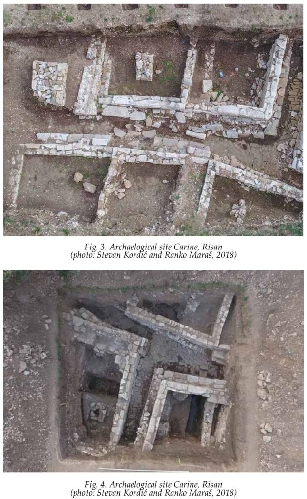
In the research campaign of 2015 2016, archaeologists made a significant discovery of Illyrian architecture previously unknown at this or any other Illyrian site. As is often the case, the find was followed by a sensational press release dubbing it “queen Teuta’s palace.”[11] Soon afterwards, however, it was asserted that for now, there is no way of telling if the “palace” indeed belonged to queen Teuta [12] until researchers published papers expressing uncertainties about these “mansion-like edifice of the local Illyrian aristocracy” (Lemke 2018: 351) were palaces at all. Regardless, discovery is unique, making it both of great scientific importance and impossible to compare to any other “palaces” since no others are known. A comparison can be made with other Illyrian structures discovered throughout the previous decade, most commonly “insulae occupied by typical Hellenistic houses” (Dyczek 2010a: 45) and a few warehouses and stores. Both residential and commercial structures suggest that Rhizon was a moderately urbanized trading and fishing town. This is further supported by various smaller artifacts, including fishing equipment and imported pottery.
Typical pre-Roman houses in Risan consisted of single floor made of stone, subdivided into two (but sometimes more) rooms in which one was used for sleeping and the other for domestic use. Purpose of specific structures and their rooms was ascertained from the material found inside them, which was often abundant and well stratified (Dyczek 2010a: 45). The houses were covered with inclined roofs, and some of them featured small yards. The structures were separated by paved streets, along which sewage canals ran, as evidenced by the two streets discovered so far – one 3 m wide and the other 1.3 m wide.
One of the houses excavated in 2010 contained a remarkable find discovered beneath a floor tile in an other wise plain room measuring 3 x 4 m. It was a clay pot containing a hoard 4656 bronze coins of King Ballaios, a figure unknown to history through any other source except coinage. Although this was the largest concentration of Ballaios’ (and Illyrian)[13] coins ever found, it was far from the first. This should come as no surprise considering that Risan was one of two places that minted them, the other being the island of Pharos,[14] likely showing us the approximate extent of Ballaios’ domain. However, the biggest source of speculation when it comes to Ballaios is the timeframe of his reign. This uncertainty created further problems for archaeologists and historians since numismatic evidence was often the only method available in determining the age of surrounding archaeological finds, such as buildings or graves. Many “believed that he was a Roman vassal who maintained the idea of Illyrian distinctiveness after the fall of Gentius’ Kingdom (168 BC)” (Evans 1885: 43, 296–298; Buzov 2011: 361–362). Now for the first time we have evidence to conclude that this assumption is incorrect as Ballaios’ reign has to be placed much earlier.
The very existence of a hoard usually suggests that its owner was pressured into making it by some calamity, and it is evident that (s)he did not recover it. This particular accumulation lacks other known variations of Ballaios’ coins, such as silver coins or those made in Pharos, suggesting that they all come from the same series, possibly the last one to bear Ballaios image. The pot contained one outstanding coin that could not have come from the outside; it came from Dyrrhachium, where such currency was in use in the 4th–3rd century BC (Dyczek 2010a: 49–50; Kowal & Lemke 2015: 221). Furthermore, the pot itself is of local, pre-Roman, manufacture, but most conclusively carbon-dating showed that the find came most probably from the 3rd century BC (Dyczek 2010a: 49–50; Kowal & Lemke 2015: 221). In addition, “a layer of burning on the floor is indicative of unrest in the town when the hoard was secreted away” as Ciolek points out, this could have been “a raid by pirates or an attack by another tribe, possibly internal strife, but equally well a calamitous conflagration that destroyed the settlement” (Ciolek 2010: 8). No battles between Illyrians and Romans at (or even near) Risan was reported by ancient historians, neither during the first three Illyrian Wars by Livy and Polybius nor later by Appian and Cassius Dio who wrote of Octa vian’s Illyrian Campaign (35–32 BC) and Bellum Batonianum (AD 6–9). We can thus conclude with fair amount of certainty that no destruction came to the city from the hands of the Romans.
ROMAN RISAN
For Risan, as for most of Illyria, there was no dramatic takeover at the end of the Third Illyrian War. As we learn from Livy, the town neither paid tribute nor it suffered some kind of reprisals since it declared itself loyal to Rome along with other neighbouring settlements (Livy XLV.26). Republican Rome expressed very little interest in controlling her proto-province of Illyricum however (Dzino 2010: 61–79). There were a few colonies such as Salona and Narona, but the rest of the territory was left to al lies among the Illyrian tribes, which allowed Rome to “exercise (some) control without involving large military resources in the establishment of direct trans-Adriatic rule” (Dzino 2010: 61–79). In the first century of the Common Era, Pliny describes Risan as a town of Roman citizens (Pliny III. 144). This, however, does not mean Risan was completely Romanised but rather that its inhabitants enjoyed full rights in the Roman Empire. As seen from the above mentioned epigraphic evidence, from some half a century after Pliny, even a relatively high-level Roman official from Risan preserved strong local identity praising the walls of his hometown as well as his local deity “Medaurus that is revered both in his homeland and here (in Africa)” (Evans 1885: 40). Conversely, there is plentiful epigraphic evidence from Risan that shows, in similar time period, a presence of Italian families and individuals of whom some came to be members of the municipal aristocracy.[15] Changes did take place but were not imposed by the Romans and took hold gradually.
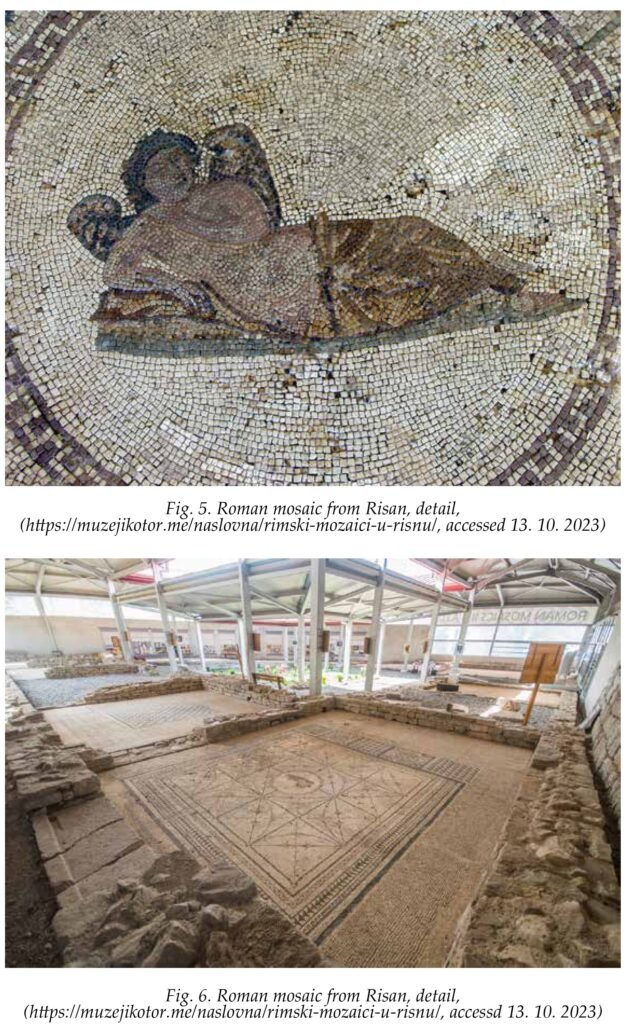
As mentioned, research so far was very unsystematic, making it difficult to establish a picture of the Roman town with any degree of certainty. The most crucial change we can as certain is that under Roman rule the town spread outside its defensive walls. If we take into consideration that the closest border of the empire was far away north along the Danube we can safely assume that the town had little use of its defences (at least) during the Principate. As a well-positioned port, Risan still held an important place in the trade network [16] but lack of security threats made it safe for its inhabitants to populate the area beyond Illyrian town limits. Thusly, approximately 500m outside the eastern cyclopean wall of Risan lies the most significant Roman era discovery and to this day the most famous archaeological site in Risan, the so-called Villa of Hypnos.
Although the site was partially described by Vialla de Sommieres, at the start of the 19th century (De Sommieres 1820), it seems to have been reburied in the meantime as neither Evans nor Richly made mention of it. It was rediscovered by Yugoslav archaeologist Dusan Vuksan in 1930’s, who published first papers describing the site, but was not completely uncovered until after Second World War (Dyczek 2010b: 51). The building, measuring 30 x 32 m, consists of an atrium surrounded by five rooms of which all but one contain elaborate mosaics. Three mosaics contain geometric shapes and patterns similar to checkerboard while one has what appears to be Hypnos (Morpheus), the god of sleep, in its very centre, giving the site its name. The house follows typical villa urbana outlay and is dated to 2nd or 3rd century of the Common Era (Vuksan 1931: 204–205; Dyczek 2010b: 51). It is not the only Roman building discovered outside the fortifications, some orifices were speculated to be temples or public building, but no publications were committed to these sites. Furthermore, most Romans finds seem to be concentrated within now inhabited part of Risan, which makes further excavation un likely for any foreseeable time. Two Roman cemeteries were partially uncovered beyond the city walls as well (Faber 1996: 103; Kowal 2011: 192).
As for the life within city walls during this period, it likely continued utilizing many of the previously existing structures that, naturally, endured some modifications over time. Such was the case with horreum (warehouse) discovered by a team of Polish archaeologists in 2014. “Around the middle of the 2nd c. AD, an architectural transformation of the building took place, as proven by coins and Roman glassware” Kowal and Lemke state while noticing that “various repairs were undertaken and new walls were added, often relying on the foundations of earlier structures” (Kowal & Lemke 2015: 213–214). One Roman addition that is described by Evans is an aqueduct that supplied water straight from the spring of the Spila River originating in a nearby cave. However, this aqueduct is not extensively discussed in contemporary scholarly sources, except for a few instances where scholars have simply cited Evans. Furthermore, I have not seen it myself when I visited the site and am inclined to believe it got destroyed in one of the earthquakes or was demolished by the locals (possibly when re laying water for the saw-mill).
CONCLUSION
The positioning of ancient Risan was strategically chosen to exert control over the bay, which, at that time, wore the same name as the city. The Illyrian builders prioritized defensibility, effectively utilizing the natural surroundings. Thanks to its strategic location and robust fortifications, Ri san became a significant centre for the regional Illyrian Kingdom and served as its capital on multiple occasions. The discovery of King Ballaios’ coin hoard might suggest that the city experienced violence. However, we can not determine the nature of the conflict that led to the concealment of the hoard for over 2000 years, if the fire was indeed a result of such a conflict. It appears that Risan’s defences were never put to the test against Rome, and the shift from being an Illyrian stronghold to a thriving Roman trade outpost occurred in a peaceful and gradual manner.
Evidence shows “the city underwent a successive urban transformation in Roman times“ and that “after the 2nd c. AD, (it) became a warehouse centre for the countryside” (Kowal & Lemke 2015: 213–214). Nevertheless, strong Illyrian cultural element persisted for at least three centuries after Roman rule was officially established. Risan continued to play a role disproportionately larger than its size during the later empire since it acted as border town between the Western and Eastern Roman Empire during the time of emperor Theodosius (reigned 379–395) (Faber 1996: 111). In the early medieval time it was a residence of bishops. The town was raided by Slavs and/or Avars between 7th and 8th century losing all of its significance until seven centuries later it became western most border town that the Ottoman Empire held on the shores of Adriatic. Today its significance is primarily as an archaeological site with noteworthy potential still waiting to be unlocked through systematic excavation, although researchers from the University of Warsaw did make tremendous progress in the past two decades.
BIBLIOGRAPHY
Primary sources
Appian. Illyrian Wars. https://www.liv ius.org/sources/content/appian/appi an-the-illyrian-wars/ (accessed 12. 10. 2023).
Cassius Dio. In Loeb Classical Library, vol. 9, translation by Earnest Cary. Harward: Harvard University Press, 1914–1927. http://penelope.uchicago.edu/Tha-yer/E/Roman/Texts/Cassius_Dio/ home.html (accessed 12. 10. 2023).
Livy. “The History of Rome from its Foundation.” In: Rome and Italy, translated by Betty Radice. London: Penguin Books, 1982.
Pliny the Elder. The Natural History, eds. John Bostock and H. T. Riley. London: Taylor and Francis, 1855. http:// www.perseus.tufts.edu/hopper/ text?doc=Perseus:text:1999.02.0137 (accessed 12. 10. 2023).
Polybius. The Rise of the Roman Empire, translated by Ian Scott-Kilvert. New York: Penguin Classics, 2003.
Strabo. Geography, translated by Horace Leonard Jones. Cambridge: Loeb Classical Library, 1917. http://penelo pe.uchicago.edu/Thayer/E/Roman/ Texts/Strabo/home.html (accessed 12. 10. 2023).
Literature
Bajtler, Marta. 2015. “Underwater finds from Risan in Montenegro: First in sight in finds of the season 2011”. Skyliss 1: 28–32.
Buzov, Marija. 2011. “The archaeological topography of the Bay of Kotor (Boka Kotorska)”. Classica et Christiana 6(2): 351–373.
Ciolek, Renata. 2010. “‘Great hoard’ of 4565 coins of King Ballaios from Rhizon”. Novensia 21: 7–13.
De Sommieres, Vialla. 1820. Voyage historique et politique au Monténégro. Par is: A. Eymery.
Dyczek, Piotr. 2008. “Rock art from Lipci, Montenegro”. Dacia LII: 189–197.
Dyczek, Piotr. 2010a. “Preliminary remarks on the archaeological context of the discovery of the ‘great hoard’ of 4656 coins of King Ballaios in Risan (Rhizon/Risinium)”. Novensia 21: 45–50.
Dyczek, Piotr. 2010b. “Roman mosaics from the Villa of Hypnos in ancient Rhizon/Risinium (Montenegro) – continuation of mosaics analysis”. Novensia 21: 51–78.
Dyczek, Piotr. 2016. “Ancient port of Rhizon/Risinum – Montenegro”. Anodos: Studies of the Ancient World 12: 79–88
Dzino, Daniel. 2010. Illyricum in Roman Politics: 229 BC – AD 68. Cambridge: Cambridge University Press.
Evans, Arthur. 1885. Ancient Illyria: An Archaeological Exploration. London: I.B. Tauris.
Faber, Aleksandra. 1976. “Prilog kro nologiji fortifikacija u primorskom Il iriku”. Jadranska obala u protohistoriji. Zagreb: Arheološki institut, 227–246.
Faber, Aleksandra. 1996. “Prilozi topografiji pretpovjesnog i antičkog naselja na području Risna”. Arheološki radovi i rasprave 12: 101–115.
Horvat, Benko. 1934–1936. “Tetradrachme ‘grada’ Damastiona iz nalaza u Risnu (Rhizon)”. Numismatika 2–4: 26–64.
Komšić, Ivo (ed). Zemlje antičkog Ilirika prije i poslije Milanskog edikta. Sarajevo: Filozofski fakultet u Sarajevu, 2014.
Kot, Malgorzata. 2013. “Report on fieldwork in the Brstanica and kriti Ponor caves near Risan, Montenegro, in 2009”. Novensia 24: 61–74.
Kowal, Tomasz. 2011. “The cyclopean walls of Rhizon. Polish archaeological excavations in 2001–2010 and Heinrich Richlý’s 19th century report”. Studia Lesco Mrozewicz ab amicis et discip ulis dedicate. Poznan: Instytut Historii UAM, 187–194.
Kowal, Tomasz. 2013. “Changes in a landscapes: a case study of three postcards from Risan”. Novensia 24: 41–60.
Kowal, Tomasz & Martin Lemke. 2015. “Risan, Montenegro, excavations in 2014”. Swiatowit: annual of the institute of archaeology of the University of Warsaw XII: 213–222.
Lemke, Martin. 2018. “Fieldwork at Risan 2015”. Swiatowit: annual of the in 73 institute of archaeology of the University of Warsaw XIII–XIV: 343–348.
Luković, Siniša. 2013. Pomorska lica Boke. Herceg Novi: Knjižara So.
Mijović, Pavle i Mirko Kovačević. 1975. Gradovi i utvrđenja u Crnoj Gori. Beograd: Arheološki institut.
Perlinska, Marta. 2013. “The potential of ‘viewshed’ analysis: Risan as a case study”. Novensia 24: 25–39.
Richly, Hainrich. 1898. “Archäologische Funde aus den Bocche di Cattaro”. Mittheilungen Der K. K. Central in Commission zur Erforschung und Erhaltung der Kunst-und historischen Denkmäle, N. F. Vienna: 143–152.
Šašel Kos, Marijeta. 2017. “The Statii of Risinium”. Illyrica Antiqua II: 171–185.
Ujes-Morgan, Dubravka. 2004. “Autonomous coinages of Rhizon in Illyria”. Actes du 4 Colloque international de Grenoble. Paris: De Boccard, 150–168.
Ujes-Morgan, Dubravka. 2008. “Ancient Greek coin finds from Risan”. Actes du V colloque international de Grenoble. Paris: De Boccard, 115–132.
Ujes, Dubravka. 1999. “Rhizon (Montenegrin Coast): A Trading Staple Town on the Crossroads of Mediterranean and Inland Balkan Routes”. Estratto della Revista. Lugano: Arti gra f iche Gaggini-Bizzozero, 203–219.
Vuksan, Dušan. 1931. “Rimski mozaik”. Almanah: Šematizam Zetske banovine 1: 201–205.
OD RIZONA DO RISINIJUMA: KRATAK PREGLED TRANSFORMACIJE JEDNE ILIRSKE PRESTONICE U RIMSKI MUNICIPIJUM KROZ PERSPEKTIVU URBANE ARHEOLOGIJE
Sažetak: Tekst se bavi analizom urbanog nasljeđa antičkog Risna, kao i time kako to nasljeđe reflektuje romanizaciju ovog nekada ilirskog grada. Topografija terena Risna i njegove bliže okoline opisana je sa osvrtom na to kako je uslovila razvoj grada i doprinijela njegovom strateškom značaju. Tekst daje osvrt na većinu najbitnijih arheoloških otkrića u domenu ilirske i rimske arhitekture, dok su zbog kratke forme drugi materijalni nalazi spomenuti samo onda kada direktno doprinose određivanju namjene neke građevine ili njene sudbine. Takav je slučaj sa ostavom novčića s likom kralja Balajosa (Ballaios), koja upućuje na jednu nasilnu epizodu iz daleke prošlosti Risna. Iako je grad bio od centralnog značaja za Ilirsko (Ardijejsko) kraljevstvo tokom ratova sa Rimskom republikom, u III i II vijeku prije nove ere, izvlači se zaključak da nije pretrpio nikakva razaranja. Nadogradnje koje su stare ilirske građevine doži vjele za vrijeme principata sugerišu kontinuirani život na ovim prostorima i mirnu tranziciju iz ilirskog u rimsko. Da je grad nastavio da prosperira uprkos gubitku strateškog značaja za novu državu u kojoj se našao, nakon perioda posredne uprave, sugeriše i samo postojanje vile urbane u neposrednoj blizini antičkog jezgra grada.
Ključne riječi: Risan, Risinium, Rhizon, ilirski ratovi, rimska arhitektura, romanizacija, rimska provincija, urbana arheologija, Hipnosova vila
ENDNOTES
[1] roberto.golovic@gmail.com.
[2] Either capitals of the Ardiaeian Kingdom changed place over time or the historians had identified the capital as any town in which Illyrian dynasts would take residence as at certain times both Risan and Scodra (and sometimes even the island of Pharos) are identified as such (Bojanovski 1988: 30; Komšić 2014: 140).
[3] Hegemony or coalition could be a more precise terms as the nature of relations between other Illyrian tribes under the Ardiaei dominance is hard to establish.
[4] “Its location, in the innermost part of the Bay of Kotor, does not afford easy visibility of the sea, a situation which could have been potentially dangerous for the town, especially during the Illyrian wars” (Perlinska 2013: 25).
[5] Appian in the Illyrian Wars, case of Narona.
[6] Austro-Hungarian Empire had turned the entire bay into a fortress at the end of 19th century. The last time the bay had seen war was during NATO campaign in Yugoslavia in 1999.
[7] “The acropolis of the Illyrian hill-fort Sv. Luka – Gošići has a visual communication with the hill-fort above Risan, as well as with the hill-fort above Mi rac” (Buzov 2011: 370).
[8] The book two of Polybius being the most contemporary and detailed source.
[9] The walls are contextually dated. According to Polybius the city was already well fortified in the time of the First Illyrian war in 3rd century BC.
[10] He was referring to a votive inscription from Africa made by a Legate of Numidia who happened to be a native of Risan who despite his position of authority in Roman hierarchy still retained strong local identity as he was praising both his hometown’s walls and its local deity (Evans 1885: 40).
[11] This was not the case just in local newspapers as the news carried internationally: https://www.dailymail.co.uk/sciencetech/article-3731233/Is-home-Illyrian-rulers-Archaeologists-discover-two-palaces-belonged-ancient-Indo-European-royalty.html (accessed 12. 10.2022).
[12] https://www.b92.net/zivot/vesti.php? yyyy=2016&mm=08&dd=20&nav_ id=1167740; https://www.glasamerike. net/a/palata-ilirskih-kraljeva/3470362. html (accessed 12. 10. 2022).
[13] Possibly one of the greatest hoards of ancient coins in general (Ciolek 2011: 8).
[14] This one varied in appearance and lacked the title king (basileus). Evans differentiated them terminologically as Rhizonian and Pharian type, and this division is in use to this day (Evans 1885: 290–296; Dyczek 2010; Ujes-Morgan 2004; Ujes-Morgan 2008).
[15] “The Statii were one of the most important families in the town […] the gentilicium is not rare and is well attested in Italy” (Šašel-Kos 2017: 171).
[16] This is supported by vast underwater and ground finds such as amphorae, stoppers, and other pieces of pottery from across the Mediterranean (Ujes 1999; Bajtler 2015: 28).
SEPARAT RADA
Separat ovog rada (pdf), objavljenog u prvom broju časopisa Konteksti kulture: studije iz humanistike i umjetnosti (2023), možete preuzeti klinom na ovaj link.